
Protected Areas/Parks Reviews
|
This page provides a listing of public reviews regarding Manitoba's parks and protected areas. These may concern decisions for new protected areas, renewal of interim protection, or the steps in park management planning. In Manitoba protected areas are protected by regulation from: logging, mining, hydroelectric, oil and gas development as well as other activities that could significantly and adversely affect natural habitat. A protected area may be designated under any of several laws in Manitoba. Visit Manitoba Conservation Parks and Natural Areas current Public Reviews Ecological Reserves, Island Parks & Parks ReviewPark Reserves
Manitoba is conducting a public review of 6 new ecological reserves. These include Woodridge Ecological Reserve (515 hectares), St. Labre Bog Ecological Reserve (3,840 hectares), St. Anne Bog Ecological Reserve (415 hectares), Piney Ecological Reserve (780 hectares); Lewis Bog Ecological Reserve expansion (4,670 hectares); Cedar Bog Ecological Reserve in the Sandilands Provincial Forest (105 hectares). Each potential ecological reserve has unique, diverse, and endangered species located insides the proposed boundaries. These ecological reserve sites appear to be surrounded by quarry leases and withdrawals. Lewis Bog and St. Labre Bog are have the greatest likelihood of sustaining their habitat and species over time. The Conservation department has explicit protection standards for the ecological reserves in their public material. Exploring or harvesting for peat is added to the language as an excluded activity. Unfortunately the text used is the protection standard for a protected area in Manitoba, not just for ecological reserves. There is also a proposal for Pelican Islands park reserve to become an ecological reserve. The ecological reserves review ends March 8, 2015. Parks
The province wishes to add 93 hectares to Moose Lake Provincial Park. The uses will be recreational, as the land use classification requires. These hectares are not protected land. The reviews above end March 8, 2015. Kinwow Bay and Sturgeon Bay park reserves, both located in the north Interlake, are to move to permanent park status. They were established in 2001, with their regulation being renewed every 5 years since. Kinwow park reserve, at 8,400 hectares, and Sturgeon park reserve, at 14,490 hectares, are both significantly smaller than the original nominated lands and waters. Both were supported for larger size by the Mining and Forestry Industries. Both were the result of a First Nation nomination for protected lands and waters. Review for these two ends April 1, 2015. Island Parks
Three island parks in Lake Winnipegosis will move from park reserve to permanent park status after these reviews. Goose Islands, Grand Island, and Pemmican Island. These also have been protected since 2001, and are known for colonial bird species habitat. Grand Island is remaining 1,035 hectares of the original home for Chemawawin First Nation, prior to hydro development flooding of Cedar Lake. The First Nation confirmed establishment of the park reserve in 2001. To review these protected areas designations from when they were first protected by regulation see Manitoba Wildlands protected areas audit chart at http://manitobawildlands.org/pa_audits.htm Manitoba Resumes Polar Bear Park Review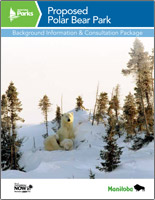 Manitoba Conservation and Water Stewardship (MCWS) has started another round of consultations about establishing the proposed Polar Bear Park around the west and south sides of Hudsons Bay. Their letter to stakeholders indicates the park would protect a highly ecologically significant landscape as well as enhance the areas reputation as an international tourism destination.
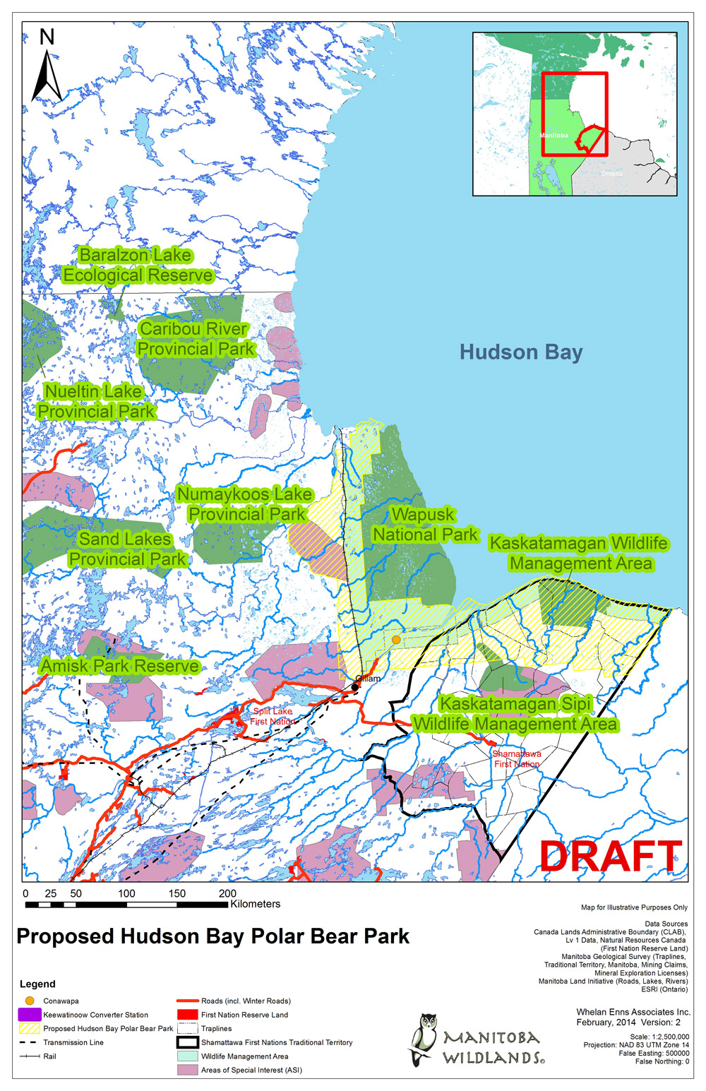
To date there is no specific information as to which lands in the three million hectare designation would be protected from development. Manitoba Hydro dams, a railway system, town sites, roads and various corridors already exist within the planning boundaries. The October 28 letter refers to legal protection for specific areas. Manitoba CWSs own ecological methods verify that isolated protected areas are not sustainable and can actually put species and ecosystems at risk if ecological standards regarding representation and size are not upheld. A set of maps are available now online and by requesting a CD. Results of Phase One park planning are also available. January 31, 2014 is the deadline for comments about Phase Two of planning. This phase is intended to guide environmental zoning. The Manitoba Parks Act requires designation by kind of park, and has a series of land use classifications for zoning inside a designation under the Parks Act. The Polar Bear Park brochure indicates there are 19 zones identified. There is no public registry system or posting of comments for public access in this planning process. Recently Cabinet signed a regulation adding a new type of park to our system in Manitoba. It appears to be for tribal parks. There was no consultation on this change to the Parks Act either. The park planning brochure states: The Manitoba government is consulting with First Nations, the Town of Churchill, local industry, tourism operators and others about the establishment of the park. To date Manitoba Wildlands has not heard of any First Nation consultations being held with the several affected First Nations. We assume that Manitoba government guidelines for Aboriginal consultations, and capacity provided through the fund for Aboriginal consultations would be in place for such consultations. Potentially then the Manitoba government has moved from Phase One to Phase Two of park planning for 3 million hectares without Aboriginal consultations. Currently Manitoba is far behind in its commitments to represent each natural region with sustainable and permanent protected areas, which can be designated under different laws or Acts. All protected areas include protection of the land under one Act, and removal of crown mineral rights under the Mines Act. Manitoba Parks still have resource management, recreation management and access zones, which are not protected lands. Recently Chitek Lake Park was made permanent, after being protected for 15 years. This kind of step does not actually increase the protected lands in Manitoba. Manitoba Wildlands filed review comments based on the consultation package for designation of this 3,000,000 hectare park west and south of Hudson Bay. The materials provided more questions than answers. No pubic registry is set up to receive and locate comments from the consultation. Information to our offices indicates that no meaningful consultation with community capacity provided are occurring with the affected First Nations. Also serious is the apparent lack of ecological and scientific context for establishment of the park. Manitobas natural region, and landscape unit system for establishment and sustainability of new parks and protected areas is absent from the materials. Even the species basis for park establishment - which is important and essential - appear to lack conservation biology understanding. It is unclear what Manitoba Conservation is doing. Perhaps a huge multi use area with mining, hydro development, communities, tourism, and some areas for certain endangered species.
View Proposed Polar Bear Park Nopiming and Manigotagan Parks to have
|
 In March 2013 Manitoba Conservation advised stakeholders that Manigotagan River Park, and Nopiming Park would be undergoing a two year process to put management plans in place. The two parks are connected. The department is putting together a list of those interested in this planning process, and affected by the Park's operation.
 The Province of Manitoba is contributing $1.8 million to Tim Horton Children's Foundation (Foundation) to assist with construction of a road, telephone, and electrical services to the new youth leadership camp near Sylvia Lake in Whiteshell Provincial Park, Manitoba.
| Level of Protection | Total Number of Units | Total Area of All Units (rounded to nearest ten- thousand) |
|---|---|---|
| All WMA UNITS current and intended | 146 | 2,210,000 Ha |
| No Protection | 36 | 500,000 Ha |
| Candidate for Protection | 15 | 1,150,000 Ha |
| Petroleum Exploration Allowed | 12 | 10,000 Ha |
| Permanent Protection | 83 | 540,000 Ha |
Many WMA units are quite small.
| Total Number of Units | Under 1,000 Ha | 1,000 to 10,000 Ha | 10,000 to 100,000 Ha | Over 100,000 Ha |
|---|---|---|---|---|
| 146 | 89 | 45 | 6 | 6 |
In recent years new WMAs have been established without protected status.
The two newest WMAs are Kaskatamagan WMA and Kaskatamagan Sipi. The Kaskatamagan WMA, announced in 2009, was an expansion and renaming of the former Cape Tatnum WMA. Although the total area of the WMA is now 561,964.08 ha, 300,925.99 ha, more than half the total area, remain lacks protection.
There are also other large WMAs waiting for designation or permanent protection. Saskeram (95,453.26 Ha) and Tom Lamb (216,417.54 Ha) remain candidates for protection, despite being identified as candidates in 1963 and 1965 respectively. Saskeram and Tom Lamb (formerly Mawdesley) WMAs are located on opposite sides of Clearwater Lake Provincial Park near The Pas, Manitoba.
View Manitoba Conservation, What is a Protected AreaView Manitoba Conservation, Protected Areas - by Type
View Manitoba Conservation, "Wildlife Management Areas"
View Manitoba Wildlands Protected Areas Grades & Audits (2000-2009)
South Saskatchewan River Delta - No Action Yet
 Manitoba Conservation put this proposed protected area to public review mid 2010, with public comments closing in October 2010. Although based on Areas of Special Interest from several years ago designed by Manitoba Conservation, with Mineral Sector reviews at the time, information about the proposed protected area is sparse. Mapping provided on the department's web pages provides no indication of Areas of Special Interest involved, the natural region location, or landscape types to be included. The area includes Red Deer Lake, along the Saskatchewan border, south of The Pas.
Requests from Manitoba Wildlands for technical information and improved mapping for this proposed protected area have gone unanswered.
First Nations communities are affected by this potential protected area. The consultation standards in Manitoba's First Nation Protected Areas MOU may or may not be intact regarding this crown lands designation. There are also many drainage projects and alterations in the proposed area, due to flooding caused by hydro generation stations, in particular the Grand Rapids dam. The Kelsey municipality is undertaking restoration, through a mitigation reserve fund with Manitoba Hydro and Manitoba, along the South Saskatchewan River. Any future designation is likely to need a management plan that addresses restoration, and accurately identifies challenges and benefits.
Important Bird Areas review has occurred, and the altered ecosystem provides nesting and habitat for many bird species. Overtime land species, large mammals, and ungulates have returned to the area.
"Manitoba Wildlands expects clarity on the status of this proposed protected area. In the meantime changes in boundary, and alterations to the plan for the area may be occurring. Priorities set for protected areas decisions 4 years ago include the South Saskatchewan River Delta," stated Gaile Whelan Enns.
View Manitoba Conservation public review page for South Saskatchewan River DeltaView Kelsey Municipality Mitigation Reserve Fund Bill
Meditation and Sylvia Lakes To Be Protected
 Manitoba Conservation Minister Bill Blaikie has announced Meditation and Sylvia lakes in Whiteshell Provincial Park will be free from development.
The two lakes were the focus of public reviews after the Tim Horton Foundation Youth Leadership Camp identified camp locations near the lakes.
Meditation Lake and the surrounding area is popular sites for canoeing and fishing. It was subject to public review as a possible site for the Tim Horton's camp. The review process led the province to keep Meditation Lake as undeveloped backcountry, with a new option for Tim Horton's camp west of Sylvia Lake.
The Tim Hortons camp at Sylvia Lake is expected to open in 2012. The lands adjacent to the Tim Hortons camp at Sylvia Lake, near Pinawa, Manitoba will not be developed or made accessible for new cottage development, states Blaikie. No licence has been issued yet for the camp at Sylvia Lake, based on the Manitoba Conservation online registry.
"A land-use category change will be initiated in the near future," according to Blaikie.
As of March 17, 2011 no regulatory changes for protect areas had been made, nor had the Whiteshell Provincial Park land use categories been updated under Manitoba's Parks Act.
"We would like to see a public review and plans for the new no logging zones in provincial parks. To date they are not protected lands, and management plans are not in place. These steps would have averted the Tim Horton's complications," stated Gaile Whelan Enns, director of Manitoba Wildlands.
View March 8, 2011 Province of Manitoba releaseView March 8, 2011 Winnipeg Free Press article
View March 8, 2011 CBC News article
 Download January 2011 Manitoba Wildlands Submission on proposed Sylvia Lake Tim Horton's Camp (PDF)
Tim Horton Sylvia Lake Camp Proposal
Manitoba Willdands commented on several deficiencies within the EA, including:
- A Management Plan for Whiteshell Provincial Park should be completed before new developments are considered.
- Consultation standards and procedures are not clear, and the consultation undertaken with affected First Nations was inadequate.
- Environmental protection plans and Department of Fisheries and Oceans approval should be in the EA filed.
- Species analysis was not adequate.
This was the second proposed camp location inside Whiteshell Park after public pressure and water quality issues forced Tim Horton's to rethink its earlier proposed location near Meditation Lake.
Download Manitoba Wildlands Comments on Tim Horton Sylvia Lake Camp Proposal (PDF)
Neultin and Colvin Parks Update
As of December 11, 2010 regulations were not all in place for these two parks. A similar problem occurred in late 2009 concerning two new wildlife management areas, as protected lands designations. These were included in the 2009 protected areas grade.
Each year Manitoba Wildlands writes the Minister responsible for protected areas establishment, alerting the minister and staff as to the timelines for the annual protected areas audit and grade.
The November Throne Speech text references the land quantum protected by the Manitoba government in the last year. Two of the protected areas included in that land quantum were included in the 2009 Manitoba protected areas audit and grade, based on regulatory steps taking in 2009.
View December 1, 2010 Manitoba Government news release
Throne Speech Announces New Protected Areas
 The November 16th 2010 Manitoba Throne Speech announced two new protected areas in the north east corner of the province. Neultin and Colvin parks are based on previous site design by Manitoba Conservation staff, and technical review with the Mining Association of Manitoba. Both candidate sites have been in the system for several years.
The Throne Speech claimed that the Manitoba government has protected one million hectares of land and waters in the last year. In the period between October 2009, and January 2010 the regulatory steps were taken to protect: Kaskatamagan and Kaskatamagan Sipi wildlife management areas (WMA). These were reported in the Manitoba Wildlands protected areas grade for 2009. (Of the 558,810 ha Kaskatamagan WMA 259,530 ha are protected, in Kaskatamagan Sipi WMA the entire 133,820 ha are protected)
As of November 30, 2010 regulatory steps to protect the two new parks are not complete, and surveys of the designations are not available. Lack of surveys and online mapping data leaves the size of these new parks unknown, as boundaries were adjusted a few times. No government press release, or website content exists for the parks announced November 16, 2010.
"We are pleased to see the Selinger government taking steps to catch up on protected areas establishment in our boreal regions. It should be noted, though, these four new protected areas are all above the tree line. Commitments to establish new protected areas in boreal regions includes where there are forests! Action for an advisory committee regarding protection of northern peatlands and their carbon reservoirs is lagging. Information that used to be transparent regarding consultations before new protected areas are announced, is not available." commented Gaile Whelan Enns, director of Manitoba Wildlands.
Manitoba Wildlands issues an annual protected areas audit and grade for government actions in our province, based on the calendar year. The same grading criteria and technical standards have been used for the Manitoba protected areas grade over the last two decades.
View Manitoba Wildlands Protected Areas Announcements pageView Manitoba Wildlands Protected Areas Grades & audit page
Little Limestone Lake Park Review
Manitoba Wildlands submitted comments on the proposed protected area designation highlighting the inadequacy of a 100 m buffer zone around the lake. Manitoba Wildlands questions consultation and public review standards. Also to date there is no classification in Manitoba's Parks Act for water.
Download August 2010 Manitoba Wildlands comments (PDF)Download Little Limestone Lake Park Reserve Information Sheet (PDF)Download April 2009 Little Limestone Lake Park Reserve Newsletter (PDF)Download June 2010 Little Limestone Lake Park Reserve Newsletter (PDF)Download August 31, 2010 Time to Respect Earth's Ecosystems, Inc. Comments (PDF)View CPAWS Manitoba website
Birds Hill Provincial Park Management Plan
Public drop-ins were held in the summer of 2010 and the public had until August 31, 2010 to submit comment sheets regarding: protection of unique and rare species in the park, the growing number of visitors to the park and the conflicts this creates, and how much and what kind of development should be allowed in the park.
A second public review period will be held in 2011 to review a draft management plan for the park.
Download September 15, 2010 Manitoba Wildlands comments (PDF)Download Comment Sheet - Birds Hill Provincial Park (PDF)Download Information Sheet - Birds Hill Provincial Park (PDF)Download Newsletter - Birds Hill Provincial Park (PDF)Birch Island & Fisher Bay Park Reserves
Birch Island Park Reserve is located on Lake Winnipegosis about 150 kilometres north of Dauphin. It includes Birch Island and a number of small islands, reefs and shoals. The area has a diverse mix of habitats, such as jack pine / black spruce ridges, mixedwood and black spruce muskeg. The small islands and reefs provide nesting habitat for many colonial nesting birds. Total park reserve area is 790 km2.
Download Birch Island Park Reserve fact sheet (PDF)Manitoba Conservation is seeking comments until September 30, 2010 about Fisher Bay park reserve, with an intention to extend the designation, and current land use classification until 2015.
Fisher Bay Park Reserve is located on the west side of Lake Winnipeg about 200 kilometres north of Winnipeg. The park reserve is roughly 841 km2 in size, of which 61,000 ha (or 72%) is the water of Fisher Bay. The remaining 23,100 ha includes land adjacent to Fisher Bay and a number of larger islands, such as Moose, Little Moose and Tamarack Islands, smaller islands, shoals and reefs.
The park reserve features treed shorelines, long sandy beaches, and islands of old-growth forest. It is home to wildlife such as bears, moose, fox, eagles and birds.
Download Fisher Bay Park Reserve fact sheet (PDF)Download September 23, 2010 Manitoba Wildlands comments (PDF)Download October 5, 2010 Manitoba Wildlands comments (PDF)Colvin Lake Park Comments
Located in the traditional territories of Northlands Dene First Nation and Sayisi Dene, the protected park would provide habitat for tundra caribou, moose, black bear, wolverine, wolf, lynx, fox, river otter, weasel, mink, and habitat for migratory bird species, such as: loons, osprey, eagles, plovers, cranes and a variety of waterfowl.
Download Colvin Lake fact sheet (PDF)Nueltin Lake Park Comments
Located in the traditional territories of Northlands Dene First Nation and Sayisi Dene, the park would provide habitat for tundra caribou, moose, black bear, wolverine, wolf, lynx, fox, river otter, weasel, mink, and habitat for migratory bird species, such as: loons, osprey, eagles, plovers, cranes and a variety of waterfowl.
Download Nueltin Lake fact sheet (PDF)Manitoba Proposes New Parks
 The Manitoba government is seeking public comments by June 25th, 2010 about two proposed parks in the north-western corner of the province.
Located in an area known as the "Land of Little Sticks", the proposed Colvin Lake Park would cover 162,800 hectares of transition area between tundra and boreal forest running along the Saskatchewan border and close to Nunavut.
The proposed 447,000 hectares Nueltin Lake Park, is located east of Colvin Lake, and the area is characterized by numerous eskers braiding across the landscape.
The two proposed parks would provide habitat for many species including moose, black bear, wolverine, wolf, lynx, fox, river otter, weasel, mink, and habitat for migratory bird species, such as: loons, osprey, eagles, plovers, cranes and a variety of waterfowl.
In addition, both proposed parks are located in the range area of the Beverly and Qamanirjuaq tundra caribou herds, and would lie within the traditional territories of Northlands Dene First Nation and Sayisi Dene.
The Conservation Manitoba webpage indicates the Constitutional rights of aboriginal people to access these areas for hunting, trapping, fishing, and other traditional pursuits will be respected, but it remains unclear if adequate consultation has taken place with local aboriginal people regarding the proposed parks.
Go to the Manitoba Conservation, Public Consultations webpage, for information on the proposals and how to file your own comments.
View Government of Manitoba Public Consultations pageView May 19, 2010 Winnipeg Free Press article
View the Colvin Lake fact sheet (PDF)
View the Nueltin Lake fact sheet (PDF)
Nopiming Development Secret
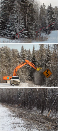 Kevin Lamoureux, deputy leader of Manitoba Liberal Party, Gaile Whelan Enns, director of Manitoba Wildlands, the Wilderness Committee, and Sagkeeng First Nation say Manitoba Hydro and Manitoba Conservation are mishandling a project to insert a new 19 kilometer power line into Nopiming Provincial Park boreal forest.
Manitoba Conservation and Manitoba Hydro ignored or circumvented requirements, and has failed to undertake consultations with Sagkeeng First Nation whose traditional lands include the proposed power corridor. Brush cutting for the corridor began December 4th despite written protests from the First Nation and local cottage owners opposed to the project.
"This process should have been handled in full public view. The land in question is in a protected provincial park, is traditional First Nations land, and yet Manitoba Conservation let a small group of pro-Hydro cottage owners lead the project," stated Kevin Lamoureux.
Whelan Enns called on Bill Blaikie, Manitoba's Conservation Minister, to remove the secrecy surrounding development decisions in provincial parks. "The new minister of conservation needs to return our parks system to consistent, fully public decision making. Secret developments in our parks must end."
View December 9, 2009 Manitoba Liberal Party press releaseDownload November 2009 Manitoba Hydro Long and Beresford Lakes Power Distribution Project: Environmental Self-Assessment Report (PDF 8 MB)Selinger Needs to Keep Road Out of Grass River Park
 Manitoba Wildlands and the Wilderness Committee are sending their final appeals of the recent environment license to bisect Grass River Provincial Park with a logging road. The license was issued to Tolko Industries mere months after logging was supposedly banned in Grass River Park. Earlier formal appeals, filed in September, were denied by Conservation Minister Stan Struthers, without explanation.
 The two environmental organizations are appealing to Premier Selinger to review this decision, and decide whether a logging road is a logging development, and whether the woodland caribou in this park deserve protection.
"Any reasonable person would expect a thoughtful citizen appeal to be responded to," said Eric Reder, Campaign Director for the Wilderness Committee. "Unfortunately, our Environment Act includes a ''weasel out'' clause, allowing our government to deny an appeal without explanation."
"We would like to see our new premier stand up for wilderness, wildlife and protected lands in the province," said Gaile Whelan Enns of Manitoba Wildlands. "This appeal to reverse a poor decision gives him his first opportunity to do so."
View September 11, 2009 Western Canada Wilderness Committee Appeal letter (PDF)
View September 11, 2009 Manitoba Wildlands Appeal letter (PDF)
View October 16, 2009 Manitoba Minister of Conservation Dismissal letter (PDF)
View October 27, 2009 full joint press release (PDF)
 2002-2014