| WOODLAND CARIBOU (Rangifer tarandus caribou) CONSERVATION STRATEGY FOR MANITOBA |
May 2000
Manitoba Conservation
| WOODLAND CARIBOU (Rangifer tarandus caribou) CONSERVATION STRATEGY FOR MANITOBA |
May 2000
Manitoba Conservation
Woodland
Caribou Conservation Strategy
Woodland
caribou were once found throughout the boreal forest regions of Manitoba. The southern portion of their range has
been significantly negatively influenced by development. Woodland caribou no longer occur in the
Sandilands, Whiteshell, south Interlake or Duck Mountain areas of the province
where development and human activity has impacted caribou. Generally, wherever herds of woodland
caribou existed and were impacted by development, they decreased in numbers or
are no longer present. The current
estimated woodland caribou population in Manitoba is 2,000-2,5000 animals,
though, at one time, there may have been more than 4,000. Because of this and similar reduction
in other provinces and territories, the western Canadian population (Alberta,
British Columbia, Manitoba, Northwest Territories, Ontario, Saskatchewan) of
woodland caribou was declared a vulnerable species by the Committee on the
Status of Endangered Wildlife in Canada (COSEWIC) in April 1984. In May, 2000, their status was uplisted
to threatened by COSEWIC.
In September,
1994, the Endangered Species Advisory Committee (ESAC) for Manitoba recommended
that woodland caribou be declared an endangered species. In November, 1996, ESAC restated their
recommendation for endangered status to ensure that critical habitats,
especially old growth forests, are protected for each herd in current and
future agreements with forestry companies. This strategy will set the groundwork for woodland caribou
conservation in Manitoba and will be integral to adopting the recommendations
of ESAC.
Presently,
there are 14 woodland caribou ranges identified in Manitoba's boreal lowlands
and boreal shield. Many areas,
where woodland caribou continue to exist, are unlikely to be impacted by human
activity in the immediate future.
In these areas, caribou are expected to continue to occur in balance
with their natural environment and to experience population and distribution
changes in response to naturally occurring habitat changes. Seven areas have been identified as low
risk ranges. Three medium risk
ranges have been identified where human activities in these areas are at low
levels, but could increase. Four
ranges have been identified as being at high risk of being negatively impacted
from human disturbance. In these
four ranges, caribou are being negatively affected and strategies are required
to mitigate these impacts, otherwise their numbers may decline. The four high risk ranges in the
province are: Kississing-Naosap lakes, Wabowden, Atikaki-Berens, and
Owl-Flintstone lakes.
The goal of this strategy is to maintain present woodland caribou numbers and distribution in the province. This will be accomplished by developing integrated management action plans for the four high risk ranges and monitoring populations and habitat of medium and low risk ranges. A process of information gathering and planning, necessary to achieve integrated caribou management with development, is outlined. This planning process has already been completed for the Owl-Flintstone lakes range and has been initiated on the Atikaki-Berens, Kississing-Naosap lakes and Wabowden ranges. Adaptive management plans for all high risk ranges will be completed within four years. These plans will prioritize woodland caribou conservation activities to be undertaken and will be developed in consultation with stakeholders. For the remaining ranges, where risk to caribou populations is lower, factors affecting ranges will be monitored. If these factors change, range status will be re-evaluated and new management action plans will be developed. This strategy will be reviewed and updated every 2 years.
EXECUTIVE SUMMARY.............................................................................................................. i
TABLE OF CONTENTS............................................................................................................ iii
LIST OF TABLES AND
FIGURES.............................................................................................. v
SECTION I: BACKGROUND............................................................................................................. 1
1. Introduction................................................................................................................................. 1
2. Concerns Regarding
Future Woodland Caribou Viability...................................................................... 3
2.1 Forest Disturbance................................................................................................................... 3
2.2 Wildfire................................................................................................................................. 3
2.3 Access................................................................................................................................... 4
2.4 Hydroelectric
Development........................................................................................................ 4
2.5 Hunting................................................................................................................................. 4
2.6 Predation............................................................................................................................... 5
2.7 Parasites................................................................................................................................ 5
2.8 Treaty Land
Entitlement........................................................................................................... 5
3. Status of Woodland Caribou Ranges................................................................................................ 6
3.1 Nelson-Hayes rivers................................................................................................................ 9
3.2 Wapisu................................................................................................................................. 9
3.3 Sisipuk-Kamuchawie............................................................................................................... 9
3.4 Kississing-Naosap lakes......................................................................................................... 11
3.5 Reed-Yawningstone-Clearwater lakes........................................................................................ 11
3.6 Wabowden........................................................................................................................... 11
3.7 Island Lake.......................................................................................................................... 12
3.8 Gunisao-Hudwin lakes........................................................................................................... 12
3.9 The Bog.............................................................................................................................. 12
3.10 Swan-Pelican lakes............................................................................................................... 12
3.11 William Lake...................................................................................................................... 13
3.12 North Interlake..................................................................................................................... 13
3.13 Atikaki-Berens..................................................................................................................... 14
3.14 Owl-Flintstone
lakes............................................................................................................. 14
4. Current Woodland
Caribou Management Actions.............................................................................. 16
4.1 Introduction.......................................................................................................................... 16
4.2 Legislation and Hunting.......................................................................................................... 16
4.3 Protected Areas...................................................................................................................... 16
4.4 Forest Wildlife
Guidelines....................................................................................................... 19
4.5 Manitoba's Forest
Plan - Towards Ecosystem Management............................................................ 19
4.6 Ecosystem Based
Management................................................................................................. 19
4.7 Canada's
Biodiversity Strategy................................................................................................. 19
4.8 Canada's National
Forest Strategy............................................................................................. 19
4.9 Provincial Woodland
Caribou Management Team........................................................................ 20
5. Specific Protection
for Four High Risk Herds................................................................................... 21
5.1 Owl-Flintstone
lakes.............................................................................................................. 21
5.2 Atikaki-Berens...................................................................................................................... 21
5.3 Kississing-Naosap
lakes.......................................................................................................... 22
5.4 Wabowden............................................................................................................................ 22
6. Actions Taken and
Future Plans..................................................................................................... 23
6.1 High Risk Ranges.................................................................................................................. 23
6.1.1 Kississing-Naosap
lakes................................................................................................... 23
6.1.2 Wabowden..................................................................................................................... 24
6.1.3 Atikaki-Berens................................................................................................................ 24
6.1.4 Owl-Flintstone
Lakes....................................................................................................... 25
6.2 Medium Risk Ranges............................................................................................................. 26
6.2.1
Reed-Yawningstone-Clearwater lakes.................................................................................. 26
6.2.2 North Interlake................................................................................................................ 26
6.2.3 Swan-Pelican
lakes.......................................................................................................... 26
6.3 Low Risk Ranges.................................................................................................................. 26
SECTION II: MAINTENANCE STRATEGY...................................................................................... 28
A. Maintenance Goal...................................................................................................................... 28
B. Objectives................................................................................................................................ 28
C. Initiatives Required to Complete
Objectives................................................................................... 29
D. Methodology to
Complete Initiatives............................................................................................. 30
E. Implementation
Responsibility...................................................................................................... 34
SECTION III: IMPLEMENTATION SCHEDULE.............................................................................. 36
SECTION IV: LITERATURE CITED................................................................................................ 38
Table 1. Conservation Risk
Assessment of Woodland Caribou Ranges in Manitoba (May 2000)...................... ..8
Table 2. Implementation
Schedule of Maintenance Tasks for High Risk Woodland Caribou
Ranges in Manitoba (May 2000)............................................................................................... 34
Figure 1. Woodland Caribou Ranges in Manitoba (May 2000)...................................................................... 7
Figure 2 Protected Areas
and Woodland Caribou Ranges in Manitoba (May 2000)......................................... 17
The woodland
caribou (Rangifer tarandus caribou) is a threatened cervid
species found in the boreal forests of Canada (Gray 1999). In Manitoba, they historically ranged
from the Manitoba/Minnesota border in southeastern Manitoba and north to
approximately 57 degrees north latitude (Seton 1909, Banfield 1961). Caribou have been extirpated from
southeastern Manitoba and no longer occur south of the Winnipeg River
(Hristienko 1985). Caribou numbers
have likely declined in all parts of the province where timber harvesting,
mining or agriculture development have occurred (Darby 1978, 1979, Shoesmith
1986, Shaefer 1988, Shaefer and Pruitt 1991, Crichton 1992). Ontario and the western Canadian
provinces have experienced similar range reductions and population
declines. In 1984, the Committee on
the Status of Endangered Wildlife in Canada (COSEWIC)¹
classified woodland caribou as a vulnerable species in western Canada (Kelsall
1984). In May, 2000, their status
was uplisted to threatened by COSEWIC.
In September,
1994, the Endangered Species Advisory Committee (ESAC) for Manitoba recommended
that woodland caribou be declared an endangered species in the province because
of concern for the long term viability of certain herds. In November, 1996, ESAC restated their
recommendation of endangered classification to ensure that critical habitats,
especially old growth forests, are protected for each herd in current and
future agreements with forestry companies. The recommendations by ESAC have yet to be adopted by the
government of Manitoba. This strategy
will set the groundwork for woodland caribou conservation in Manitoba and will
be integral in implementing the recommendations of ESAC.
In 1993, the
Manitoba Wildlife Branch prepared a report on the woodland caribou which
outlined an action plan to conserve the species in Manitoba (Johnson
1993). It recommended the
development of a woodland caribou management team, consisting of Regional
Wildlife Managers and a Wildlife Branch biologist. This team was struck in 1994 and was charged with the task
of drafting this strategy report.
The report sets priorities for the study and management of woodland
caribou. The goal is to maintain
woodland caribou at contemporary levels of abundance and distribution in
Manitoba.
Many factors
affect woodland caribou populations.
Habitat is key to maintaining any viable wildlife population. Woodland caribou require extensive
stands (1000's of square kilometres) of mature forest (KPMG 1995). In particular, the areas used for
wintering, calving, rutting and seasonal movements are essential to the viability
of a herd. A conservation strategy
must identify all real and potential impacts and their cumulative effects, and
develop a set of clear objectives to avoid or minimize the impacts on critical
and sensitive woodland caribou habitats.
The possible effects of climatic change on woodland caribou are not
discussed in depth in this strategy, though in the long-term global warming may
impact range use. Alvo (1998)
pointed out that global warming and increased development may affect the
frequency and intensity of forest wildfires, which could ultimately change the
distribution of the southern discontinuous permafrost limit that may be related
to woodland caribou habitat use.
Woodland
caribou depend upon mature forests as habitat for most of their seasonal range
use and movements (Bergerud 1974, Carbyn 1968, Darby 1978, 1979, Shoesmith and
Storey 1977, Stardom 1977). As
well, woodland caribou use both arboreal lichens and forest-floor lichens,
which occur primarily in mature forests, as a major source of food. Therefore, woodland caribou generally
inhabit lichen-rich areas of the boreal forest (Hristienko 1985). The most important disturbances to its
habitat are those that affect the lichens: wildfire and clear-cutting (Alvo
1998). Cooperative forest and
wildlife management must occur to prevent specific herds from being extirpated
from their native ranges. Timber
harvesting, mining activities, utility (hydro, telephone) corridors and roads
have the potential to be detrimental to and fragment caribou habitat. The role mature forests play as a
barrier to the influx of other ungulates and their associated predators into
caribou range is as important as overall habitat availability (Bergerud 1974,
Bergerud and Mercier 1989, Cringan 1957).
As well, habitat changes which favour moose (Alces alces) and
white-tailed deer (Odocoileus virginianus) may also increase the
prevalence of parasites pathological to woodland caribou. Protected or managed areas are needed
to safeguard caribou from human disturbance. To ensure that caribou populations are sustainable, forest
management plans need to integrate the habitat selection and life history
requisites of caribou.
Forest
wildfires are a natural part of forest succession and wildfire affects woodland
caribou and their habitats. In the
long term (>60-100 years), wildfires serve to rejuvenate areas for future
caribou use. In the short term
(<60-100 years), burned habitats decrease access to winter forage due to the
loss of lichens, an increase in snow thickness and hardness, and the
accumulation of deadfalls (Shaefer 1988).
The length of time of this effect depends on several factors, most
importantly on the productivity of soil regime of the area and the length of
the growing season. This may
eventually lead to caribou displacement.
If adjacent, alternative mature forest areas do not exist, then the
affected caribou may not persist.
Mining, hydro
and forestry developments all require roads and trails to transport people and
supplies to and from resource extraction sites. Roads, trails and other linear corridors, including hydro
transmission line rights-of-way and mining exploration lines, initially
constructed for resource development and extraction, allow easier access to
formerly "remote" tracts of caribou habitat. Linear corridor development has the
potential to increase mortality from legal or illegal hunting and facilitate
movement of predators into caribou range, thereby, increasing predation (James
and Stuart-Smith 2000). Road and
other linear corridor construction and use can disturb caribou and lead to
population and range fragmentation, and partial range abandonment. Linear corridor placement plans must
consider the seasonal ranges, travel corridors and seasonal concentration of
caribou. In addition, when roads
and other linear corridors are no longer needed for their initial purposes,
closures will be implemented to reduce the above mentioned impacts.
Hydroelectric
power dams impact woodland caribou by flooding habitat. Transmission lines, to
a lesser extent, also cause a reduction in the available habitat for
caribou. Human activity associated
with large scale construction can cause caribou to abandon traditionally used
sites.
Most cervid
species in Manitoba can normally sustain some human harvest. The sustainable level of harvesting is
dependent on the population size, reproductive rate and all mortality factors. Since caribou occur at low densities,
have a low reproductive rate, and can experience significant mortality from
predation or parasites, uncontrolled hunting can impact a population. Licenced hunting of woodland caribou is
no longer permitted in Manitoba except in Game Hunting Area (GHA) 3 (for
description of lands encompassed by GHA's see, Hunting Areas and Zones
Regulation, Manitoba Regulation 220/86 made under The Wildlife Act), where
woodland caribou range (of a forest/forest ecotype, as defined by Gray (1999))
overlaps with the coastal herd of the Pen Island caribou (a forest/tundra
ecotype, as defined by Gray (1999)). The number of woodland caribou harvested
in this area is small because of the limited entry hunting season (75
licences). As well, in years with
less than average snowfall, most of the harvest that does occur are caribou
from the more abundant coastal Pen Island range. Pen Island caribou travel farther west into Manitoba during
these years.
First Nations
hunting occurs on all ranges except in GHA 26 (Owl-Flintstone lakes range),
where a regulation has prohibited the hunting of woodland caribou by anyone
since 1991. Current levels of
First Nations harvest are not believed to be excessive, but, because of the
herding behaviour of caribou, the potential for serious impacts exists where
access is available. Harvests
levels will be developed and monitored; this is particularly important for
ranges at high and medium risk. If
hunting is considered the primary cause of caribou population declines in any
area, a regulation restricting hunting will be considered. Opportunities for woodland caribou
co-management initiatives with First Nation communities will be encouraged.
Illegal
hunting occurs periodically, but based on field reports, it does not appear to
be a significant mortality factor.
Woodland
caribou are a natural prey species for such predators as timber wolves (Canis
lupus) and black bears (Ursus americanus). Predation, when compounded with other
mortality factors, can decrease herd numbers. Habitat disturbance can increase the carrying capacity for
other ungulates, e.g., moose and white-tailed deer, and result in increased
predator numbers and increased predation on caribou. Roads, hydro transmission lines and off-road vehicle routes
can enhance access for predators into caribou habitats, resulting in increased
predation.
In parts of
Manitoba, white-tailed deer are infected with brainworm (Parelaphostrongylus
tenuis). This parasite has little
effect on deer, but caribou are highly susceptible to neurological damage
caused by the worm (Anderson 1971, Anderson and Strelive 1968, Behrend and
Witter 1968). Prior to 1995, deer
were expanding their range northwards due to a series of mild winters and
improved habitat conditions resulting from timber harvesting, land clearing and
wildfire. This deer and parasite
expansion is a threat to caribou on the eastside of Lake Winnipeg. Caribou are particularly susceptible to
this impact because the spread of brainworm would likely occur concurrent with
increased predation resulting from higher deer numbers. Other pathogens known to infect caribou
may have a higher risk of being transmitted to caribou because of increasing
white-tailed deer numbers. One
such parasite is the giant liver fluke (Fascioloides magna) which is
prevalent in southeastern Manitoba.
The impacts of these diseases will need to be monitored.
Canada
entered into various treaties with First Nation communities in the late 1800s
and early 1900s. Under those
treaties, Canada agreed to set aside a certain amount of land as reserve
lands. To date, not all of those
lands have been transferred and a process is now ongoing to transfer those
lands to First Nation communities (Manitoba Northern Affairs 1997). Some of the land considered for
transfer is important to caribou.
Opportunities to co-manage woodland caribou with First Nations will be
essential for their continued presence in affected ranges.
Most
literature on the woodland caribou in Manitoba refers to individual caribou
herds. For example, Johnson (1993) suggested that there were 27 distinct herds
in the province. Subsequent
investigations have shown that the population dynamics and dispersal movements
of woodland caribou are more complex than previously thought. Combined with the difficulties involved
in obtaining reliable data, the concept of managing caribou herds is not
practical. A more pragmatic
approach is to apply an adaptive conservation strategy using the habitat-based
concept of caribou ranges.
These are herein defined as areas of contiguous habitat with similar
characteristics that support populations of woodland caribou. This report recognizes 14 woodland
caribou ranges in Manitoba (Fig. 1).
Population
estimates are given for each range based on observations of animals during
aerial caribou or other resource inventories, ground observations by
biologists, hunters, trappers and others and/or aerial track counts (Table 1). These estimates are not based on any
statistically valid sampling or census technique but are the best available.
There are
many real and potential threats to the continued viability of woodland caribou
ranges in Manitoba. Wildfire is a
threat to habitat for all of the ranges.
Other important threats are summarized for each range in Table 1 and
include habitat loss and fragmentation from timber harvesting, hydro
development, mining and increased access from linear corridors, excess
mortality from First Nations hunting, increased access, parasites and
predation.
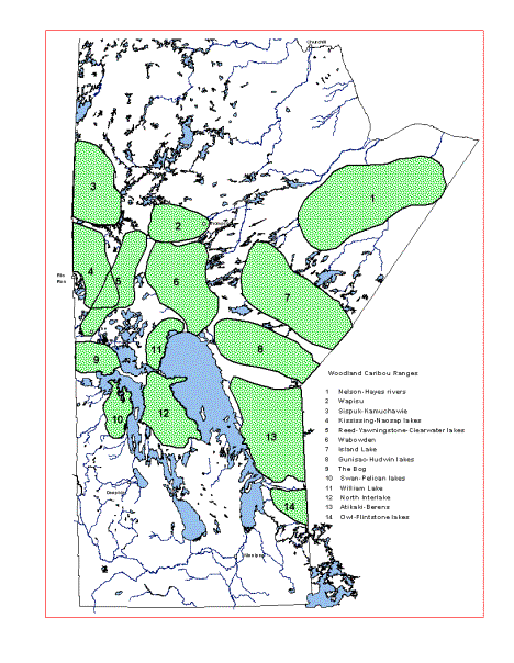
Figure 1. Woodland Caribou Ranges in Manitoba (May 2000).
|
RaNge |
Risk level |
pOP'n SIZE |
tHREATS |
||||||
|
Timber Harvesting |
Hydro |
Mining |
First Nations Hunting |
Access |
Parasites |
Predators |
|||
|
Kississing-Naosap
lakes |
High |
100-200 |
Yes |
Yes |
Yes |
Yes |
Yes |
No |
Yes |
|
Wabowden |
High |
150 |
Yes |
Yes |
Yes |
Yes |
Yes |
No |
Yes |
|
Atikaki-Berens |
High |
300-500 |
Yes |
No |
Yes |
Yes |
Yes |
Yes |
Yes |
|
Owl-Flinstone
lakes |
High |
65-75 |
Yes |
No |
Yes |
No |
Yes |
Yes |
Yes |
|
|
|
|
|
|
|
|
|
|
|
|
Reed-Yawningstone-Clearwater
lakes |
Medium |
100-150 |
Yes |
No |
Yes |
Yes |
Yes |
No |
Yes |
|
Swan-Pelican
lakes |
Medium |
50-75 |
Yes |
No |
No |
No |
No |
No |
No |
|
North
Interlake |
Medium |
50-75 |
Yes |
Yes |
No |
No |
No |
No |
Yes |
|
|
|
|
|
|
|
|
|
|
|
|
Nelson-Hayes
rivers |
Low |
N/A |
No |
No |
No |
No |
No |
No |
No |
|
Wapisu |
Low |
100 |
Yes |
Yes |
No |
No |
No |
No |
No |
|
Sisipuk-Kamuchawie |
Low |
100-200 |
Yes |
No |
No |
Yes |
No |
No |
No |
|
Island
Lake |
Low |
500-1000 |
No |
No |
No |
Yes |
No |
No |
No |
|
Gunisao-Hudwin
lakes |
Low |
250-500 |
No |
No |
No |
No |
No |
No |
No |
|
The
Bog |
Low |
50-75 |
No |
No |
No |
Yes |
No |
No |
Yes |
|
William
Lake |
Low |
25 |
Yes |
Yes |
Yes |
Yes |
Yes |
No |
No |
That part of
northeastern Manitoba between the Nelson and Hayes rivers and south of the Cape
Tatnam Wildlife Management Area is winter range to migratory coastal caribou (a
forest/tundra ecotype) and year round range to woodland caribou. No estimate of woodland caribou numbers
is available.
This range is
remote and accessible only by plane, boat or off-road vehicle, or by a winter
road to Shamattawa. Major factors,
which could affect the future of this range, are hydroelectric development,
road development and mining. The
risk to caribou on this range is considered low.
The Wapisu
range occurs west of Thompson.
Caribou occur south of Provincial Road (PR) #391 and north of Setting
Lake, as far west as Highrock and Burntwood lakes and east, as far as
Provincial Trunk Highway (PTH) #6.
The population is estimated to be a minimum of 100 animals.
This range is
remote except for one major road, PR #391, which connects Thompson, Nelson
House, Leaf Rapids and Lynn Lake.
Road development for timber harvesting began in 1997 and timber
harvesting in 1999 on the eastern periphery of the range. Wildfires had an impact on much of this
range in 1989. Occasional
opportunistic hunting of caribou does occur within this range but the harvest
is not significant. A power dam is
proposed at the outlet of Wuskwatin Lake.
In 1999, assessment activities for a generating station, road and power
transmission line began.
Major factors
that may affect this range in the future include roads, hydroelectric
development, mining and timber harvesting. The risk to caribou is currently considered low, but as
development proceeds this risk will be elevated.
The Sisipuk-Kamuchawie range occurs in northwestern Manitoba near the Saskatchewan border and extends from Vandekerckhove Lake on the north to just south of the Churchill River. It is home to 100-200 caribou. This range is intersected by the Hudson Bay Railway (HBR) line to Lynn Lake, PR #396 from Lynn Lake to Fox Mine and PR #394 from Lynn Lake to Kinoosao. However, little impact on this range has occurred. Timber harvesting commenced here in 1995. First Nations harvest of caribou is occurring, however, a co-management agreement is in place for most of this caribou range.
Major factors
that may affect this range in the future include timber harvesting, mining and
hydroelectric development. The
risk to caribou on this range is presently low.
This range
covers an area of boreal forest within the Canadian Shield from Kississing Lake
south to the lowland mixed forest which includes Grass River Provincial
Park. The population is estimated
to be 100-200 caribou.
The Sherridon
rail line, a 230 kV hydro right-of-way, and PTH #10, PTH #39 and the Sherridon
road traverse this area. Extensive
timber harvesting from the 1970’s to present and a major forest wildfire in
1989 have impacted this area.
Further timber harvesting is planned in the Naosap-Peterson lakes area
that will further impact the range.
Timber harvesting began in 1994 on Collins Point on the north shore of
Kississing Lake raising additional concerns. Much of the north and northeast shore of Kississing Lake and
large islands, such as Moose Island, are also identified for future timber
harvesting. Some caribou harvest
occurs by First Nations people.
First Nations hunters harvest 10-20 caribou annually from this herd,
with most of the harvest taking place along the Sherridon road and the winter
road between Pukatawagan and PTH #10.
Some mortality due to hunting and vehicle collisions also occurs along
PTH #39.
The caribou
on this range are considered at high risk because Tolko Manitoba Inc. (formerly
Repap Manitoba Inc.) has identified the Naosap lake area for timber harvesting
over the next 10 years; there is also the potential for increased mortality
from predation and hunting.
This range
includes an area of mixed wood forests and lowlands from the
Yawningstone-Mitchell lakes area northeast to the Canadian Shield around Reed
Lake. The caribou population is
estimated to be 100-150 animals.
Extensive
timber harvesting and forest wildfires during the 1970’s and 1980’s, in the
Yawningstone-Mitchell lakes area, has had some short term negative impact on
the southern portion of this range.
Timber harvesting has occurred for some years in the Reed Lake area and
continues in the Dolomite Lake area.
Some mortality occurs from hunting and vehicle collisions along PTH #39
and the Mitchell Lake road. A
portion of this range is within Grass River Provincial Park and Cormorant
Provincial Forest.
Future
threats to this range could include loss of habitat due to ongoing timber harvesting,
increased road access, and continued human disturbances on and around Reed
Lake, a known caribou calving and summer area. The caribou on this range are considered at medium risk.
The Wabowden
range occurs south of the Wapisu range and extends as far south as the north
end of Lake Winnipeg. The number
of caribou is estimated at 150 animals.
This range
has well‑developed access and is traversed by PTH #6, PTH #39 and PR
#373. The HBR Churchill line,
Bipole I, Bipole II, a 230 kV hydro transmission line and associated
right-of-ways also cross this range.
Tolko Manitoba Inc. has been and continues to log this range. The area had an operating mine near
Clark Lake which was decommissioned in the mid-1980’s. However, mining exploration activities
occur annually. Some vehicle
mortality and opportunistic harvesting by First Nations hunters occurs. Because of timber harvesting and
ongoing mining exploration, the risk to caribou on this range is considered
high.
The Island
Lake range occurs south and east of Norway House and extends to the Ontario
border. There are several
scattered caribou groups with an estimated total population of 500-1000
caribou. There has been little
industrial disturbance on this range.
Wildfires burned some of this range in 1989 and some opportunistic
harvesting of caribou occurs.
Factors that may affect this range in the future include road
development, mining, timber harvesting and hydro transmission lines. Industry has expressed an interest in
forest harvesting in this area.
Because of the limited immediate development plans the caribou on this
range are considered at low risk.
The
Gunisao-Hudwin lakes range occurs east of the north end of Lake Winnipeg and
extends eastward to the Ontario border.
The number of caribou in this range is estimated at 250-500
animals. Little impact has
occurred here in the past. Future
development in this range is not expected in the near future, but industry is
interested in forest harvesting in this area. The caribou on this range are at low risk.
The Bog range
extends from Westray south to Red Deer Lake, and from Cedar Lake to at least
the Saskatchewan border. The population in this range is estimated to be 50-75
animals.
Historically,
timber harvesting has been limited in most of this range due to the limited
volumes of merchantable timber.
Cutting has occurred on both sides of PTH #10 and the mature timber has
been virtually depleted. Other
factors affecting caribou mortality in this range, include hunting by First
Nations people along PTH #10 and PTH #60, vehicle mortality and wolf
predation.
The Bog range
is the least likely to experience dramatic habitat changes and mortality is
low. The overall risk to caribou
on this range is low.
The
Swan-Pelican lakes range extends from Cowan east to Lake Winnipegosis along the
west and north shores of Lake Winnipegosis and west to the eastern edge of Swan
Lake. Caribou occur in small
numbers, principally between Pelican Lake, Pelican Bay and Lake
Winnipegosis. The population is
estimated to be 50-75 caribou.
Recent timber
harvesting within this range has been minimal. Some limited caribou harvest by First Nations people may
occur.
At present,
forest companies have not logged this range. However, if local forest harvest quotas are maintained, this
forest will be impacted. Long-term
Tolko Manitoba Inc. forest management plans call for extensive timber
harvesting and road development in this general area. Given the limited softwood fibre remaining nearby, it is
likely that forest harvest will proceed within the next 10 years and the
population is at some risk. Due to
the potential timber harvesting, caribou on this range are considered to be at
medium risk.
This range
includes a lowland area of mixed forest around William Lake southward to Grand
Rapids and east to Lake Winnipeg.
Approximately 25 caribou occur in this range.
Forest
wildfires in 1961 impacted a significant portion of this range. Only limited timber harvesting has
occurred around William Lake to date.
Mineral exploration in this area has increased in the last few years.
Little is
known about this caribou range, but if timber harvesting continues to expand
around William Lake, the risk to caribou on this range will change from low to
medium risk.
Suitable
range for woodland caribou exists in the northern portion of the Interlake in
the area bounded by Dauphin River on the south, Lake Winnipeg on the east, Lake
Winnipegosis on the west and Cedar Lake on the north. Observations suggest that 50-75 animals occur on this range.
Although a
considerable amount of the range was burnt by a large forest wildfire in 1961,
there has been much less impact by wildfire since that time, and older age
forests occur in remnant stands throughout the area. Low intensity forest harvesting occurs by winter access
only. The only permanent road
through the range is PTH #6.
Several hydro transmission corridors pass through and provide some
access to this range. Mortality
caused by hunting and vehicle collision is low. Predation by wolves is probably the most significant source
of mortality. The presence of
other species including elk (Cervus elaphus), white-tailed deer,
moose and wood bison (Bos bison athabascae) on the caribou range
may support a relatively high population of wolves that might prey on caribou
in specific seasons.
There is
ongoing timber harvesting in the Katimik Lake area and along PTH #6. However, Chitek Lake area has been
declared a park reserve and no timber harvesting is allowed. Woodland caribou habitat is at medium
risk at this time. However, should
timber harvesting operations expand or a major wildfire occurs, the status of
caribou on this range could change from medium to high risk.
The
Atikaki-Berens range includes an area of northern coniferous forest within the
Boreal Shield ecozone and the Lac Soul Upland ecoregion. Caribou are restricted on the west by
Lake Winnipeg and extend eastward into Ontario. They occur south as far as the
Wanipigow River and north of the Poplar River. They are known to calve on islands in various lakes,
including, Sasaginnigak, Fishing, Wrong, Carr-Harris and Family lakes and on
rock outcrop "islands" between the Berens and Pigeon rivers. Wintering areas include Shallow Lake,
Beaver Creek, Atiko Lake, Loon Straits and Berens River area. Fall concentrations have been
identified in several areas, including south of Kautunigan Lake. The population is estimated to be
between 300-500 animals.
This range is
remote except for the Rice River all-weather road and a few winter roads which
bisect caribou winter habitat.
Some forest harvesting is occurring on the fringe of this range. Present mortality sources are First
Nations hunting, wolf and bear predation and vehicle collisions.
The major
future habitat threat is timber harvesting. Pine Falls Paper Company will require significant volumes of
their wood from this range in the next 10 years due to the development of a
thermal mechanical pulping (TMP) process.
The TMP process will enable the Pine Falls Paper Company to use much
more pine than they presently do.
This will increase the demand for harvesting wood in caribou habitat
areas. However, timber harvesting
is prohibited within Atikaki Wilderness Park. The Bipole III hydro transmission line corridor was destined
to traverse through this area and could bisect important wintering areas,
resulting in increased access to caribou by First Nations hunters and wolves,
as well as, habitat loss.
Important habitats may be bisected and First Nations harvest of caribou
may increase with the proliferation of winter roads. As well, the construction of a proposed all-weather road on
the eastside of Lake Winnipeg, with access roads to aboriginal communities, may
also impact important habitats and lead to increased harvest. Loss of habitat due to timber
harvesting, and increased mortality due to increased access, places these caribou
at a high risk.
The
Owl-Flintstone lakes range occurs east of Lake Winnipeg and extends into
Ontario and from the Wanipigow River south to the Winnipeg River. This range has a population of
approximately 65-75 animals.
Presently,
the current core winter and summer ranges for this herd are relatively
undisturbed from forestry activities and access. However, disturbance in the range around these core areas is
extensive and results from forestry activities, road development, recreational
development, mining and wild rice harvesting. This may be the primary reason why this range remains
occupied by caribou. Timber
harvesting and wildfires have diminished the winter range to approximately
eight townships. Further loss of
winter habitat could be critical to the survival of caribou in this range. Access to the timber harvesting
operation at Happy Lake has been controlled to protect the caribou and other
resources in the area. Caribou are
protected by legislation from harvest, including First Nations hunters, within
this range. Mortality occurs
through vehicle collisions and by wolf predation. There is a risk of parasites impacting caribou as
white-tailed deer emigrate into forest harvested areas used by caribou.
Merchantable
timber within the winter range is in demand by the Pine Falls Paper Company, as
well demand for pine will increase with the development of TMP. Increased mortality due to brainworm
and increased predation are serious threats. Caribou on this range are at high risk.
General and
specific management initiatives have been or are occurring that enhance the
survival of woodland caribou in Manitoba.
Canada's Biodiversity Strategy and Federal Species at Risk initiatives
proclaim the importance of ecosystem integrity and sustaining all components of
biological systems. Woodland
caribou is also a species which has been listed as threatened by COSEWIC. These initiatives have done much to attract
the attention of stakeholders with an interest in the boreal forest including
the general public, industry and governments. All have a vested interest in conserving this species.
Manitoba
Wildlife Legislation provides for regulations which protect woodland caribou
and enables a sustainable harvest of them. Manitoba Forest Wildlife Guidelines and Manitoba's Forest
Plan provide for general protection and management of caribou habitat in
forests which are harvested. Both
documents specifically refer to management prescriptions for woodland
caribou. Other initiatives such as
the Protective Areas Initiative and the Ecosystem Base Management Initiative in
Ecoregion 90 recognize woodland caribou as an important forest wildlife species
with specific habitat requirements that must be sustained to maintain viable
populations.
Site specific
management initiatives are occurring in the four areas where caribou are at
risk (Table 1). Studies are
underway to delineate range use and critical habitats (wintering, calving and
calf-rearing) and determine numbers of animals which occupy these ranges. This information is being used to
direct and/or restrict development in these areas. Forest industry companies, Manitoba Hydro, First Nations and
local people are actively involved in these initiatives.
Woodland
caribou are classified as big game under The Wildlife Act. Licenced hunting seasons for all
caribou herds (except GHA 3) have been closed since 1992. Hunting of caribou by First Nations
people does occur on most ranges, except on the Owl-Flintstone lakes range, GHA
26 (eastside of Lake Winnipeg), where it has been prohibited since 1991.
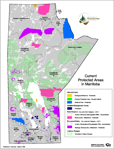
Manitoba has
a number of protected areas (Fig. 2, Manitoba Natural Resources 1997b) which
overlap with caribou ranges. In
some protected areas, timber harvesting, mining, hydroelectric development and
other activities that negatively impact caribou habitats are prohibited. Protected areas include ecological
reserves, national parks, and some, or parts of, provincial parks and wildlife
management areas. Within some of
these areas, caribou habitat is protected from development. Presently eight of the 14 woodland
caribou ranges are partially within protected areas. The land base of several of the protected areas in these
ranges is small and not significant.
In 1990,
Manitoba committed to the establishment of a network of protected areas. Plans are to protect areas within each
natural region of the province. A
network of protected lands is being assembled that strives to conserve
ecosystems and maintain biodiversity.
Several of the protected areas fall within woodland caribou ranges. This species has been considered as an
important species when selecting study areas for the Protected Areas
Initiative. Therefore, woodland
caribou ranges will be receiving greater protection from this initiative. But protected areas are not expected to
protect all of the required habitat necessary to sustain woodland caribou
populations in Manitoba.
Establishment
and management of new protected areas is occurring in consultation with First
Nations people. First Nations will
assist in identifying areas of cultural, spiritual and ecological significance
including traditional ecological knowledge related to woodland caribou.
Figure 2. Protected Areas and Woodland Caribou Ranges in Manitoba (May 2000).
The Manitoba
Forest Wildlife Guidelines are being rewritten. The revised guidelines will incorporate contemporary views
of wildlife management, including ecosystem-based management, and will be more
proactive in protecting woodland caribou habitat. In the new document, woodland caribou are designated a
regional focus species in the Northwest, Northeast and Eastern Manitoba
Conservation regions. Therefore,
habitat maintenance for woodland caribou species will be one of the main
requirements for forest management practices in these regions. This will also benefit other wildlife
species which have habitat needs similar to those of woodland caribou as
outlined by Kuhnke and Watkins (1999).
This document
moves forest management from an economic view of forests to a recognition of
the "needs for sustainability, biodiversity, and integration - with forest
health and forest integrity as fundamental objectives". In the plan, woodland caribou are
identified as an important indicator of forest health and the woodland caribou
HSI model is referenced as a tool for monitoring caribou habitat within a
managed forest. Forest management
practices that accommodate woodland caribou, which require very large blocks of
unfragmented mature forest habitat, are outlined in the plan.
A
pilot project on the eastside of Lake Winnipeg will provide future direction to
government and industry in the development and application of ecosystem-based
management in Manitoba. Woodland
caribou are considered a key element in this pilot project.
Canada, the
provinces and territories signed a commitment in 1995 entitled "Canada's
Biodiversity: A commitment to its Conservation and Sustainable Use". Manitoba is a signatory to this
document which commits the province to the Canadian Biodiversity Strategy.
Manitoba's participation in this strategy is an indication of the province's
commitment to global conservation of biodiversity, which includes woodland
caribou.
The National
Forest Strategy (1998) is meant to guide Canada's efforts in sustainable forest
management. The goal of the
strategy is to "maintain and enhance the long-term health of our forest
ecosystems, for the benefit of all living things both nationally and globally,
while providing environmental, economic, social and cultural opportunities for
the benefit of present and future generations". Manitoba is a signatory to this document and is committed to
the sustainable forest management principles identified in this strategy.
Manitoba
Conservation established a Woodland Caribou Management Team consisting of
Regional Wildlife Managers and Wildlife Branch staff. This team sets priorities for the study and management of
woodland caribou in the province.
The status of each caribou range was reviewed and the degree of threat
assessed. Four of the 14 ranges
are identified as being at risk due to habitat changes from timber harvesting
and other threats (Table 1). These
are the Owl-Flintstone lakes, Atikaki-Berens, Kississing-Naosap lakes and
Wabowden ranges. Specific programs
have been initiated in these ranges to identify the distribution of caribou and
critical habitat use. Data will be
used to integrate caribou conservation with forest management. Immediate and future action plans for
these ranges are identified in this document.
This range is
included in the Pine Falls Paper Company Forest Management Licence (FML) and is
subject to all existing forestry, wildlife and environmental guidelines.
An Integrated
Forestry Woodland Caribou Management Strategy (TAEM 1995) is used to direct
timber harvesting on this caribou range.
This strategy was developed and is supported by Manitoba Conservation
(Policy Coordination, Forestry, Parks and Natural Areas, Wildlife Branch and
Operations Division), Pine Falls Paper Company and Time to Respect Earth's
Ecosystems (TREE).
Part of this
caribou range is in Nopoming Provincial Park. Under park regulations, overnight camping on all islands on
both Flintstone and Black lakes (calving and summer rearing areas) is
prohibited. Proposed development
or possible restrictions in the caribou range within the park is ongoing and
subject to review.
Access by the
general public to the winter range has been closed by a control structure on
the Happy Lake Road. All proposed
resource development roads in the area must be approved by Manitoba
Conservation.
The Pine
Falls Paper Company's Environmental Impact Assessment recognizes caribou as an
important species in this area and must consider caribou habitat needs in
planning activities and documents.
Location of roads, timber harvesting areas and time of harvest have been
modified to minimize impacts on caribou.
Manitoba
Hydro recognizes that woodland caribou are at risk in this area and have
assisted with studies to determine impact of hydro corridors on caribou
movements.
The following
organizations are funding specific projects and participating on a woodland
caribou project advisory committee on caribou management in this area: Manitoba
Conservation (Policy Coordination, Forestry, Parks and Natural Areas, Wildlife
Branch, Operations Division and Environment Division); Pine Falls Paper
Company; Manitoba Model Forest; Manitoba Hydro; Time to Respect Earth's
Ecosystems (TREE); Lac du Bonnet Fish and Game; and the University of Manitoba.
This range is
within areas utilized by the Pine Falls Paper Company. The future expansion of the Pine Falls
Paper Company's Forest Management Licence must be approved by Manitoba
Conservation and will be subject to all forestry, wildlife and environmental
guidelines and regulations.
Part of this
range is in the Atikaki Provincial Park.
Atikaki Provincial Park is designated as a wilderness park. Proposed development or restrictions in
the caribou range within the park will be subject to review. Manitoba Conservation, Manitoba Hydro
and Manitoba Model Forest are funding specific projects on caribou management
in this area.
This range is
included in the Tolko Manitoba Inc. FML and is subject to all existing
forestry, wildlife and environmental guidelines.
The Tolko
Manitoba Inc. Environmental Impact Assessment recognizes woodland caribou as an
important species in this area.
The company has considered caribou habitat requirements in plan
development and has modified cutting plans where conflicts with caribou may
occur. Tolko Manitoba Inc. and
Manitoba Conservation have developed a woodland caribou mitigation plan for the
Naosap operating area encompassing, large leave-areas of habitat, special
considerations for woodland caribou travel corridors and vehicle access
control. As well, the plan identifies
ongoing research to assess the effectiveness of the plan.
Part of this
range is in the Grass River Provincial Park. Proposed development in the caribou range within the park
will be subject to review.
The following
organizations are currently participating in research initiatives aimed at
enhancing caribou management by funding projects in this area: Manitoba
Conservation (Forestry, Parks and Natural Areas, Wildlife Branch and Operations
Division); Tolko Manitoba Inc.; Laurentian University and Manitoba Hydro.
This area is
included in the Tolko Manitoba Inc. FML and is subject to all existing
forestry, wildlife and environmental guidelines.
The Tolko
Manitoba Inc. Environmental Impact Assessment recognizes caribou as an important
species in this area and considers them in plan development and has modified
cutting plans in response to concerns.
Tolko
Manitoba Inc. and Manitoba Conservation are participating in caribou management
activities in this area.
This range is
considered to be at high risk because of extensive timber harvesting plans
(REPAP 1996). To minimize the
effects of these developments, habitat use will be delineated and an integrated
forest caribou management plan developed.
Aerial
surveys were conducted in March 1991 and during the winters of 1993-94, 1994-95
and 1995-96 to gather information on numbers and distribution of caribou in the
area (Cross 1996, Cross and Smith 1995, Cross and Smith, in press).
A
spring, summer and fall assessment of caribou habitat use in a portion of the
Kississing-Naosap lakes range occurred in 1995 and 1996 (unpublished data,
Northwest Region files). In
February 1996, five female woodland caribou were fitted with very high
frequency (VHF) radio-transmitters.
Fifteen more radio-transmitters were deployed on caribou in 1998 and 11
in 1999. These caribou will be
monitored on a regular basis and their distribution mapped. This information will provide more
precise data on seasonal habitat use and movements of caribou in this area.
Historical
data were analyzed to describe habitat use in the Reed-Naosap lakes region
(Benoit 1996). Relocation data
from recently radio-collared caribou are also being compiled and analyzed by a
Laurentian University graduate student as a requirement for a Master of Science
(M.Sc.) degree. The focus of this
study will be to determine seasonal patterns of habitat use, selection of
specific forest community types and disturbance by roads, hydro transmission
lines and other linear corridors.
These analyses enable Manitoba Conservation to identify and recommend
actions to protect caribou habitat in the area.
Habitat
availability and distribution will be identified using Forest Resource
Inventory (FRI) and the woodland caribou habitat suitability index (HSI)
model. Road retirements and
hunting prohibitions for First Nations people will also be considered to reduce
caribou mortality.
A study of
this caribou range, to better determine numbers, distribution, movement
patterns, key habitats, mortality, and response to timber harvesting, is
underway. This study is
continuing. Development of an
adaptive management action plan for this range has been initiated. A five-year forest harvesting plan to
mitigate impacts to woodland caribou in the Naosap operating area has recently
been completed with Tolko Manitoba Inc.
The Naosap operating area represents less than 10 percent of the total
area of this range but is scheduled for intense forest harvesting operations
over the course of the next five years.
Future plans
for timber harvesting in this range are significant (REPAP 1996). Because of habitat loss and ongoing
mineral exploration, the risk to this range is considered high.
Two
cooperative caribou forest management studies were completed in this
range. The first study was
initiated in 1995 by Manitoba Conservation with Repap Manitoba Inc. and the
University of Saskatchewan. Ten
female caribou were fitted with VHF telemetry collars in 1995, with an
additional five radio-transmitters deployed in 1996. An ongoing monitoring program is occurring. Movement and distribution data were
used to identify important habitats, movement corridors, caribou use of
previously harvested areas and extent of the range used. A caribou habitat map is being
developed using FRI and monitoring data.
Progress to date has been reported (Brown 1998, Brown et al. in press,
Elliott 1997, Elliott and Brown 1996).
All results will be published in a graduate student's M.Sc. thesis. Once data have been analyzed, an
integrated woodland caribou and forestry management plan for this range can be
developed in collaboration with Tolko Manitoba Inc.
In 1997, a
second study was initiated by Manitoba Conservation with the University of
Manitoba, Natural Resource Institute (NRI). The structure of, and fidelity to, calving/calf rearing
habitat were measured and described in areas inhabited by cow-calf pairs. The results of this study were
published as a NRI practicum (Hirai 1998) and will assist in developing forest
management strategies for caribou habitat for this range in conjunction with
Tolko Manitoba Inc. This will also
form the basis for the development of a caribou summer habitat model for the
Manitoba lowlands.
Other
management initiatives needed to reduce mortality include road retirements and
hunting restrictions. The
implementation of these initiatives is ongoing and requires consultation with
stakeholders.
Loss of
critical habitat areas through wildfire and timber harvesting, and potential
increase in mortality from unregulated hunting and wolf predation as a result
of increased access development, place these caribou at high risk.
VHF
radio-telemetry studies on these caribou were undertaken in the 1970's and from
1987 to 1992. These studies
provided information on important habitats, movement corridors and extent of
the range used. The caribou
habitat in the area can be further identified by developing a caribou habitat
map using FRI and a recently developed HSI model (Palidwor and Schindler
1995). This will occur as part of
the integrated woodland caribou/forestry planning process. Once habitat suitability has been
mapped, an integrated woodland caribou and forestry management plan can be
developed in collaboration with the Pine Falls Paper Company. This management plan will also include
input from other stakeholders.
As part of a
joint study between Manitoba Conservation, Manitoba Hydro, Pine Fall Paper
Company and the Manitoba Model Forest, VHF radio-collars were put on two
caribou at Sasaginngak Lake in 1999, and in February, 2000, seven global
positioning system (GPS) radio-telemetry collars and two VHF radio-collars were
placed on caribou south of the Bloodvein River between Shallow Lake and Atiko
Lake. Data collected from these
animals will help to determine seasonal range use, important habitats and
identify travel corridors on this range.
Relocation data will also help to refine and further validate the HSI
model for this caribou range.
Other
management initiatives needed to reduce mortality include road retirements and
hunting restrictions. The
implementation of these initiatives will require consultation with
stakeholders. Hunting prohibitions
for First Nations people may be considered to reduce caribou mortality.
The
Owl-Flintstone Lakes range is the most impacted caribou range in Manitoba. Timber harvesting, access development,
campgrounds and other recreational activities have all significantly impacted
the periphery of this range, while the current core habitat areas are less
impacted. Caribou numbers have
remained relatively unchanged for the last 30 years, likely because core
habitat areas remain somewhat undisturbed. However, continued timber harvesting operations and
increases in other activities put this range at high risk.
VHF
radio-telemetry studies, in the late 1980s and early 1990s, provided
information on wintering areas and limited information on calving and migration
routes. This information was used
to develop a winter habitat suitability index (Palidwor and Schindler 1994,
Palidwor and Schindler 1995). An
integrated caribou/forestry management strategy has been developed (TAEM 1995). The strategy addresses various concerns
related to forestry and caribou and defines specific habitat objectives and
management actions within a caribou management zone. The process of developing this strategy involved the
establishment of a project advisory committee consisting of industry,
non-government organizations and government representatives. The committee also functions as a
catalyst for proactive research and management initiatives with the goal of
maintaining woodland caribou numbers and range.
A joint study
between Manitoba Hydro, the Manitoba Model Forest and Manitoba Conservation,
using GPS radio-collars in 1995/96 and 1996/97 (TAEM 1996, TAEM 1997), has
provided an opportunity to further understand winter, summer and migratory
habitat use by caribou. As well,
Martinez (1998) examined winter habitat use by eight GPS collared caribou on
this range. Berger et al. (2000)
conducted further analysis of the relocation data from these GPS collared
caribou and 3 others. The
conclusions of their report were based on the analysis of more than 17,500
relocation records. An
experimental forest harvesting program occurred in 1996 and 1997 to
specifically monitor the impacts of harvesting on caribou. Nine VHF radio-collared caribou
continue to be monitored in this range.
An aerial
population survey of this range was conducted in February, 2000. A total of 61 caribou were sighted
during the survey flights. This
number is consistent with the estimated number of 65-75 caribou which occupy
this range.
This range is
considered at medium risk because no major timber harvesting operations are
planned for this range in the foreseeable future.
Several
department studies have focused on this range since the 1960s. Information collected, coupled with an
HSI model, will assist in identifying important remaining caribou
habitats. The HSI model for woodland
caribou needs to be validated for this range. This will enable the development of an integrated woodland
caribou and forestry management plan for this range and direct development away
from sensitive areas should forestry operations be initiated.
This range is
considered at medium risk at this time due to limited access and limited
forestry operations in the area.
However, this status could change if forestry operations or access
increases. Information on caribou
on this range is limited and a caribou monitoring survey is needed to gather
preliminary information on numbers and distribution of animals.
This range is
at medium risk since immediate forestry operations are unlikely. Monitoring programs that examine
population numbers and habitat use should be developed in this range to assess
populations before the commencement of timber harvesting activities. The HSI model for woodland caribou may
be used in this range to identify possible sensitive winter habitat areas. The HSI model needs to be validated for
this range.
The
Nelson-Hayes rivers, Wapisu, Sisipuk-Kamuchawie, Island Lake, Gunisao-Hudwin
lakes, The Bog and William Lake ranges are low risk ranges and will not be
managed other than through opportunistic monitoring. Caribou habitats could be monitored by assessing the impact
of wildfires or any changing land use patterns. If land use changes are proposed for these ranges, the
impact on caribou numbers and habitats will be assessed. Any decline in caribou numbers or
habitat on these ranges will result in reassessment of the risk category. A management strategy would be
developed for ranges that become high risk.
Although the
risk of woodland caribou becoming endangered in the province is not immediate,
several challenges need to be addressed to ensure that populations remain at
present levels. To achieve this
goal, specific objectives must be undertaken. It is recognized that restoring woodland caribou to their
original distribution in Manitoba is not feasible.
GOAL: To maintain viable woodland caribou
populations on existing ranges and at present population levels, thereby,
contributing to the maintenance of ecological processes and Manitoba's
biological diversity.
Specific objectives
to attain this goal include the following:
1. Monitor
ranges to ascertain population dynamics.
Identify habitat supply, quality and land use changes. Priority will be given to ranges
considered at high risk.
2. Monitor
impacts of predators and parasites on woodland caribou and where necessary
implement strategies to address impacts.
3. Develop and
apply an integrated woodland caribou management strategy for those caribou
ranges where forest harvesting or other land use development is occurring or is
imminent.
4. Define areas
where woodland caribou conservation takes priority over resource use and other
wildlife species.
5. Develop
public support through education programs, media productions and cooperative
management arrangements with First Nations and other stakeholders.
6. Assess
effectiveness of applied initiatives in achieving the stated goal.
7. Modify
initiatives, as needed, based on new information on caribou biology, forest
management and results of management strategies taken.
Objective 1.
Monitor existing populations, habitat and land use changes.
1.1
Population ecology.
1.1.1 Identify woodland caribou ranges.
1.1.2 Identify seasonal distribution and travel
corridors.
1.1.3 Identify seasonal habitat associations.
1.2
Habitat.
1.2.1 Identify and define the habitat used with
the aid of FRI and Forest Ecosystem Classification (FEC).
1.2.2 Develop and validate winter and summer
HSI models.
1.2.3 Identify
distribution and relative abundance of caribou habitat supply.
1.3 Natural
disturbance.
1.3.1 Identify
habitat changes due to wildfire.
1.4
Land use.
1.4.1 Identify
timber demands.
1.4.2 Identify
hydro development.
1.4.3 Identify
mining and other development.
1.4.4 Evaluate
significance of linear corridors and access.
Objective 2.
Assess impacts of predators and parasites on woodland caribou.
2.1 Monitor wolf and
black bear populations on woodland caribou ranges.
2.2 Monitor
impacts of parasites on woodland caribou.
Objective 3.
Develop range-specific integrated woodland caribou management strategies.
3.1 Manage
habitat through establishment of protected areas.
3.2 Manage
habitat through development of integrated forest management plans.
3.3 Manage
vehicular access through road abandonment, access control or road
closure.
3.4 Manage
predation by habitat or predator management.
3.5 Manage
parasites by habitat or normal host management.
Objective 4.
Define areas where woodland caribou conservation takes priority.
4.1
Manage habitat through establishment of woodland caribou conservation areas.
4.2 Manage
wildlife species within woodland caribou conservation areas.
Objective 5.
Develop public support through information and education programming.
5.1
Establish integrated woodland caribou management committees.
5.2 Develop
and distribute status reports, public service announcements and
brochures on caribou issues relating to tasks identified in this
strategy.
Objective 6.
Assess the effectiveness of applied strategies.
6.1
Monitor population status and trend.
6.2
Monitor the habitat available for woodland caribou.
Objective 7.
Modify strategies in response to effectiveness of previous prescriptions.
In the past,
woodland caribou have suffered destruction of their habitat, excessive hunting,
predation and the introduction of new parasites into their range. As a result, woodland caribou no longer
occupy parts of their historic range.
Southeastern Manitoba will probably never be reoccupied by caribou
because of conflicting land use and due to the introduction of brainworm. However, the current range and numbers
of woodland caribou can be maintained if there is a commitment to do so from
government, non-government organizations, industries and the public. The following methodology outlines the
information and actions needed to support maintenance programs for woodland
caribou in Manitoba.
1. Monitoring
existing populations, habitat and land use changes.
1.1 Population
ecology.
1.1.1 Identify woodland caribou ranges.
Past
information, from casual observations and planned or opportunistic aerial
surveys, have been used to identify geographical areas important to
caribou. More reliable information
will be collected by additional surveys and radio-telemetry technologies.
1.1.2 Identify seasonal distribution and travel
corridors.
Aerial
surveys are useful for providing information on winter distribution of caribou
but are of limited value at other seasons of the year, due to reduced
visibility under coniferous and deciduous tree cover and lack of visible
tracks. Information on seasonal
distribution and travel corridors can best be obtained by aerial relocation of
radio-collared animals or by ground observations of animals, tracks or other
sign.
1.1.3 Identify seasonal habitat associations.
When seasonal
distributions and travel corridors of animals have been identified, habitat
associations will be determined by site evaluations and/or from vegetation
maps. FRI data exists for all the
critical caribou ranges.
1.2 Habitat.
1.2.1 Identify and define the
habitat used using FRI and Forest Ecosystem Classification (FEC).
All caribou
ranges that will be logged have associated FRI data available. This provides an opportunity for
effective management planning by identifying known critical caribou habitat
associations. These habitat data
can be enhanced by using the FEC for Manitoba (Zoladeski et al. 1995).
1.2.2 Develop and validate winter and summer
habitat suitability index models.
A winter
habitat suitability model already exists for use on the eastside of Lake
Winnipeg and a preliminary summer model has been developed. However, due to diversity in forest
composition and landscapes, models will need to be further validated and
modified for use in other locations.
1.2.3 Identify distribution and relative
abundance of caribou habitat supply.
Using HSI
models, the abundance and distribution of caribou habitat will be determined.
This information is essential to identify present and potential future caribou
distribution.
1.3 Natural disturbance.
1.3.1
Identify habitat changes due to wildfire.
Wildfires are
a frequent natural occurrence on caribou ranges. Manitoba Conservation Fire Management maintains a GIS
database on wildfires. This
database will be used to monitor habitat loss from wildfire for each woodland
caribou range.
1.4 Land use.
1.4.1 Identify timber demands.
Since timber
harvesting will have the greatest man-caused impact on the future of caribou
ranges, forest cutting plans will be identified to predict future impacts on
caribou. Timber harvesting may
cause direct loss of habitat, or result in increased access and thereby
impacting caribou by increasing predation, hunting and area avoidance.
1.4.2 Identify
hydro development.
Hydro
development is planned on some caribou ranges. The extent of the development and impact on each caribou
range will be identified and assessed.
It is essential that this process be undertaken in the early stages of
development planning so that mitigative measures can be initiated.
1.4.3 Identify
mining and other development.
Mining,
cottage development, tourism operations and other development will occur on
some caribou ranges. The extent of
each development, its impact and the cumulative effects of other developments
on caribou ranges will be identified and assessed. Identifying these developments, early in their planning
process, is essential to ensure that mitigative measures can be undertaken.
1.4.4 Evaluate significance of linear corridors
and access.
The impact of
linear corridors and increased access is an important negative factor on some
caribou ranges. All linear
corridors and access routes will be identified and their impact to caribou
distribution assessed.
2. Assess impacts of predators and
parasites on woodland caribou.
2.1 Monitor
wolf and black bear populations on woodland caribou ranges.
Wolf and black bear population trends and
distribution will be monitored opportunistically. A systematic method of surveying
predators will be conducted for ranges where predators are a significant
concern. Mortality due to
predation will be estimated using data from radio-collared caribou.
2.2 Monitor
impacts of parasites on woodland caribou.
The impact of
harmful parasites to woodland caribou (as well as the distribution of their
normal hosts) will be monitored opportunistically. A systematic method of monitoring this impact will be
developed and used for ranges where parasites are a significant concern.
3. Develop
range-specific integrated woodland caribou management strategies.
3.1 Manage
habitat through development of integrated forest management plans.
Once caribou
and timber company needs are identified, plans will be developed to identify
ways and means of accommodating forestry while securing the integrity of each
range.
3.2 Manage
vehicular access through road abandonment, access control or road closures.
Vehicular
access into caribou range can fragment the range and lead to increased
mortality from human harvest and vehicle collisions. Access routes and linear corridors also function as travel
routes for predators. Once caribou
distributions are identified, strategies will be developed to reduce the
negative effects of access development.
3.3 Manage
predation by habitat or predator management.
Although
caribou can maintain their populations with a limited amount of predation,
changes in numbers of alternative prey or increased predator access can lead to
increased predation resulting in population decline. Operational plans shall be modified to discourage an increase
in alternative prey habitat and predator access. Predator management may be considered on ranges where
caribou numbers are at critical levels and predator control will assist in
their recovery.
3.4 Manage
parasites by habitat or normal host management.
The
introduction of new parasites into caribou ranges by the expansion of their
normal host species can lead to increased mortality of caribou. Operational plans shall be modified to
discourage an increase in habitat favoured by the normal host species. Hunting seasons can be altered to
increase the harvest of the normal host species on woodland caribou ranges.
4. Define
areas where woodland caribou conservation takes priority.
4.1 Manage
habitat through establishment of woodland caribou conservation areas.
Habitat
considered critical for the continued viability of a woodland caribou range
will be protected by legal designation.
No development will occur within these protected areas. Calving areas, travel corridors,
wintering areas or other habitat may be considered for protection.
4.2 Manage
wildlife species within woodland caribou conservation areas.
Wildlife
species within woodland caribou conservation areas will be managed to maintain
or enhance caribou survival. This
may mean implementing hunting or trapping seasons to increase the harvest of
predators or normal host species and habitats preferred by these species.
5. Develop
public support through information and education programming.
5.1 Establish
integrated woodland caribou management committees.
Integrated woodland caribou management committees will be established for each of the high risk ranges. These committees will foster information exchange and function as a forum for sharing ideas and concerns about caribou management.
5.2 Develop
and distribute status reports, public service announcements and brochures on
caribou issues relating to tasks identified in this strategy.
Information
related to caribou and caribou conservation issues will be made available to
the public. This information will
be provided in appropriate formats to ensure a broad audience. Public and client/stakeholder awareness
of caribou management is essential for the success of the strategy.
6. Assess
the effectiveness of applied strategies.
The impacts
of most management practices (including forestry, access, predator, parasites,
etc.) on woodland caribou are poorly understood. As management actions are undertaken, caribou responses to
those management actions will be evaluated by changes in distribution or mortality.
6.1 Monitor
population status and trend.
Caribou population trends and
distribution will be monitored by surveys and radio- telemetry relocation data.
6.2 Monitor
the habitat available for woodland caribou.
Forest
harvesting, wildfires, and other land use changes will occur on caribou ranges
and these changes will be mapped to repeatedly assess caribou habitat
availability and distribution.
7. Modify
strategies in response to effectiveness of previous prescriptions.
As the
effectiveness of the strategies are evaluated, those which are effective will
be continued while those which are ineffective will be modified or abandoned.
Manitoba
Conservation is responsible for the protection and management of woodland caribou
in Manitoba. The Wildlife Branch
of Manitoba Conservation develops policy and management guidelines, and
provides overall provincial direction for woodland caribou protection and
management. Operations Division of
Manitoba Conservation implements and delivers programs, at the field level, for
this species.
Other
agencies, industry, First Nations and other stakeholders have an interest,
expertise and resources to devote to caribou management. These groups have a role to play in
caribou conservation. Industry has
a specific responsibility to become actively involved in caribou conservation
by partnering in or being the sole proponent of conservation initiatives and
research. Industry involvement
shall be an integral component of yearly operations and a requirement of doing
business on the landscape. This
will require a significant commitment of funds and manpower from industry.
The Eastern
Region Integrated Woodland Caribou Management Committee reviews caribou
management activities and research in the region and provides advice to
Manitoba Conservation. This
committee has representatives from Manitoba Hydro, Manitoba Model Forest,
Manitoba Conservation (Policy Coordination, Forestry and Wildlife branches and
Operations Division), Pine Falls Paper Company, TREE, First Nations and local
wildlife associations. This
integrated approach has worked well in assuring that information is shared with
all stakeholders and all concerns are recognized.
It is
recommended that integrated management committees be established for all high
priority caribou ranges.
Membership on each will vary due to the different stakeholders in each
geographical area but may include wildlife and forestry staff, industry
representatives, First Nations and environmentalists.
The
implementation schedule for ranges at high risk (Table 2) outlines maintenance
tasks to be undertaken by 2003/2004.
It will be used for the scheduling of all activities and as the basis
for the distribution of funding between projects. The various tasks follow the outline described in Section II
of this document and are grouped together under general categories.
It should be
noted that tasks outlined are those which should be undertaken to ensure the
continued viability of woodland caribou ranges at high risk. Existing budgets and manpower dedicated
for woodland caribou initiatives will have to be increased in order to complete
these tasks. These actions will be
regularly reviewed, progress updated and future tasks planned at the annual
meeting of the Manitoba Conservation Woodland Caribou Management Team.
Table 2.
Implementation Schedule of Maintenance Tasks for High Risk Woodland Caribou
Ranges in Manitoba (May 2000).
|
ACTION |
KISSISSING-NAOSAP |
WABOWDEN
|
ATIKAKI-BERENS
|
OWL-FLINTSTONE
|
||||
|
Start |
Complete |
Start |
Complete |
Start |
Complete |
Start |
Complete |
|
|
Background Studies |
||||||||
|
Range |
Ongoing |
2001/2002 |
1995/1996 |
1998/1999 |
1986/1987 |
Ongoing |
1986/1991 |
2000/2001 |
|
Seasonal Distribution/Travel Corridors |
Ongoing |
2001/2002 |
1995/1996 |
1998/1999 |
1986/1987 |
Ongoing |
1986/1991 |
2000/2001 |
|
Habitat Association |
1996/1997 |
2001/2002 |
1997/1998 |
2000/2001 |
2001/2002 |
2002/2003 |
1986/1991 |
2000/2001 |
|
Habitat Used - FRI & FEC |
1996/1997 |
2001/2002 |
1997/1998 |
2000/2001 |
2001/2002 |
2002/2003 |
1994/1995 |
Done |
|
Habitat Suitability Models |
1999/2000 |
2002/2003 |
1999/2000 |
2000/2001 |
1994/1995 |
1997/1998 |
1994/1995 |
Done |
|
Distribution, Abundance |
1996/1997 |
2001/2002 |
1995/1996 |
2000/2001 |
2001/2002 |
2002/2003 |
1994/1995 |
Done |
|
Natural Disturbance - Wildfire |
Ongoing |
Ongoing |
1950/1951 |
Ongoing |
Ongoing |
Ongoing |
Ongoing |
Ongoing |
|
Timber Demand |
1997/1998 |
Ongoing |
1997/1998 |
Ongoing |
2001/2002 |
2002/2003 |
1994/1995 |
Ongoing |
|
Hydro, Mining & Other Development |
Ongoing |
Ongoing |
1997/1998 |
Ongoing |
2000/2001 |
Ongoing |
1994/1995 |
Ongoing |
|
Linear Corridors, Access |
Ongoing |
Ongoing |
1995/1996 |
Ongoing |
Ongoing |
Ongoing |
Ongoing |
Ongoing |
|
Parasites, Predation |
Ongoing |
Ongoing |
Ongoing |
Ongoing |
Ongoing |
Ongoing |
Ongoing |
Ongoing |
|
Implementation Action |
||||||||
|
Integrate Forestry & Habitat |
1997/1998 |
Ongoing |
2000/2001 |
2001/2002 |
2001/2002 |
2003/2004 |
1994/1995 |
Done |
|
Manage Vehicle Access |
Ongoing |
Ongoing |
Ongoing |
Ongoing |
Ongoing |
Ongoing |
Ongoing |
Ongoing |
|
Manage Predation |
Ongoing |
Ongoing |
1997/1998 |
Ongoing |
Ongoing |
Ongoing |
Ongoing |
Ongoing |
|
Manage Parasites |
N/A |
N/A |
N/A |
N/A |
2002/2003 |
Ongoing |
2000/2001 |
Ongoing |
|
Establish Woodland Caribou Conservation Areas |
1984/1985 |
Ongoing |
2001/2002 |
Ongoing |
2002/2003 |
Ongoing |
2001/2002 |
Ongoing |
|
Information Action |
||||||||
|
Establish Stakeholder Committee |
1999/2000 |
Ongoing |
1995/1996 |
Ongoing |
1999/2000 |
Done |
1994/1995 |
Done |
|
Education Information |
1998/1999 |
Ongoing |
1996/1997 |
Ongoing |
1999/2000 |
Ongoing |
1994/1995 |
Ongoing |
|
Evaluate Action |
||||||||
|
Caribou Status |
Ongoing |
Ongoing |
2000/2001 |
Ongoing |
1998/1999 |
Ongoing |
Ongoing |
Ongoing |
|
Habitat Status |
1997/1998 |
Ongoing |
1997/1998 |
Ongoing |
1999/2000 |
Ongoing |
Ongoing |
Ongoing |
|
Modify Plans |
Ongoing |
Ongoing |
Ongoing |
Ongoing |
Ongoing |
Ongoing |
Ongoing |
Ongoing |
Alvo, R.
1998. National status evaluation of 20 selected animal species inhabiting
Canada's forests. Gavia Biological Services Report for The Canadian
Pulp and Paper Association, The Biodiversity Convention Office & The
Canadian Forest Service.328 pp.
Anderson,
R.C. 1971. Neurologic disease in reindeer (Rangifer tarandus tarandus) introduced
into Ontario. Can. J. Zool. 49:159-166.
Anderson,
R.C. and U.R. Strelive. 1968. The experimental transmission of Pneumostrongylus
tenuis to caribou (Rangifer tarandus terraenovae). Can. J.
Zool. 46:503-510.
Banfield,
A.W.F. 1961. A revision of the reindeer and caribou Genus Rangifer. Nat. Mus.
Can. Bull. 177. Bio. Ser. No. 66. 137 pp.
Benoit, A.D.
1996. A landscape analysis of woodland caribou habitat use in the Reed-Naosap
lakes region of Manitoba (1973-1985). MNRM. Thesis, University of Manitoba,
Winnipeg, Manitoba.
Berger, R.,
I. Martinez-Welgan and M. Wisener. 2000. Analysis of global positioning system
(GPS) relocation data (1995-1999) for the Owl Lake woodland caribou. Part A:
Synopsis of technical papers. Wildlife Resource Consulting. 88 pp.
Bergerud,
A.T. 1974. Decline of caribou in North America following settlement. J. Wild. Manage.
38:757-770.
Bergerud,
A.T. and W.E. Mercier. 1989. Caribou introductions in eastern North America.
Wildl. Soc. Bull. 17:111-120.
Behrend, D.F.
and J.F. Witter. 1968. Pneumostrongylus tenuis in white-tailed deer in
Maine. J. Wildl. Manage. 32:936-966.
Brown, K. 1998. Range distribution and critical
habitats of woodland caribou in central Manitoba: implications for forestry
practices. Progress Report 1997/98. Manitoba Natural Resources. 15 pp.
Brown, K., C.
Elliott and F. Messier. in press. Woodland caribou population range and
distribution in central Manitoba: implications for forestry practices. in Proceedings
of the 8th North American Caribou Workshop, April 20-24, 1998. Whitehorse,
Yukon.
Carbyn, L.N.
1968. Woodland caribou survey in the Bloodvein River region of eastern
Manitoba. Manitoba Dept. of Mines and Natural Resources, Wildlife Branch.
Crichton,
V.F.J. 1992. Woodland caribou management in Manitoba, Canada. in: Global
trends in wildlife management. B. Bobek, K. Perzanowski, and W. Regelin (eds).
Trans. 18th IUGB Congress, Krakow 1987. Swiat Press,
Krakow-Warszawa. Vol. 2: 193-196.
Cringan, A.
1957. History, food habits and range requirements of woodland caribou of
continental North America. Trans NA Wildlife Conf. 22:485-501.
Cross, D.W.
1996. Woodland caribou survey in west central Manitoba, March 1991. Manitoba Natural Resources Manuscript
Report No. 96-07W 13 pp.
Cross, D.W.
and C.E. Smith. 1995. Woodland caribou winter distribution, habitat use
assessment and population estimate Kississing Lake area, Feb. 1993 and Feb.
1994. Unpublished Manuscript. Manitoba Department of Natural Resources.
Cross, D.W.
and C.E. Smith. in press. Woodland caribou winter distribution, habitat use
assessment and population estimate Naosap Lake Area. Manitoba Department of
Natural Resources.
Darby, W.R.
1978. The seasonal movements and population ecology of woodland caribou (Rangifer
tarandus caribou (Gemlin)) in southeastern Manitoba: A final report
with discussion and recommendations concerning park development.
Darby, W.R.
1979. Seasonal movements, habitat utilization and population ecology of
woodland caribou (Rangifer tarandus caribou Gemlin) in the
Wallace-Atkins Lake region of southeastern Manitoba. M.S. Thesis, University of
Manitoba, Winnipeg, Manitoba. 187 pp.
Elliott, C. 1997. Range distribution and critical habitats of woodland
caribou in central Manitoba: implications for forestry practices. Progress
Report 1996/97. Manitoba Natural Resources. 38 pp.
Elliott, C.
and K. Brown. 1996. Range distribution and critical habitats of woodland
caribou in central Manitoba: implications for forestry practices. Progress
Report 1995. Unpublished Manuscript. Manitoba Department of Natural Resources.
Gray, D.R.
1999. Updated Status Report on the Woodland Caribou (caribou des bois) Rangifer
tarandus dawsoni and Rangifer tarandus caribou in Canada.
COSEWIC. 37 pp.
Hirai, T.
1998. An evaluation of woodland caribou (Rangifer tarandus caribou) calving
habitat in the Wabowden area, Manitoba. MNRM Thesis, University of Manitoba.
Winnipeg, Manitoba. 119 pp.
Hristienko,
H. 1985. The impact of logging on woodland caribou (Rangifer tarandus
caribou): a literature review. Manitoba Natural Resources, Wildlife Branch,
Technical Report No. 85-03.
James, A.R.C.
and A.K. Sturat-Smith. 2000. Distribution of caribou and wolves in relation to
linear corridors. J. Wildl. Manage. 64(1):154-159.
Johnson, C.S.
1993. Woodland caribou in Manitoba. Manitoba Natural Resources, Wildlife
Branch, Technical Report No. 93-02.
Kelsall J.P.
1984. Status Report on Woodland Caribou Rangifer tarandus caribou. COSEWIC. 99
pp.
KPMG
Management Consulting. 1995. Manitoba's Forest Plan Towards Ecosystem Based
Management. Report to Manitoba Natural Resources. Vol. 3:83-85.
Kuhnke, D.H.
and W. Watkins. 1999. Selecting wildlife species for integrating habitat supply
models into forest management planning in Manitoba. Nat. Resour. Can., For.
Serv., North. For. Cent., Edmonton, Albert. Inf. Rep. NOR-X-357. 56 pp.
Manitoba
Natural Resources. 1997a. An Action Plan for Manitoba’s Network of Protected
Areas 1996-1998. 10 pp.
Manitoba
Natural Resources. 1997b. Five Year Report to the Legislature on Wildlife;
April 1, 1992 - March 31, 1997. 47 pp.
Manitoba
Northern Affairs. 1997. Manitoba Treaty Land Entitlement Framework Agreement
Implementation Handbook. 28 pp.
Martinez,
I.M. 1998. Winter habitat use by woodland caribou (Rangifer tarandus caribou) in the Owl
Lake region of Manitoba. MNRM Thesis, University of Manitoba. Winnipeg,
Manitoba. 105 pp.
National
Forest Strategy 1998-2003: Sustainable Forests A Canadian Commitment. 1998.
Prepared for Canadian Council of Forest Ministers. 46 pp.
Palidwor,
K.L. and D.W. Schindler. 1994. Habitat suitability models within Manitoba Model
Forest Region: First Approximation Woodland Caribou (Rangifer tarandus
caribou) March 1994.
Palidwor,
K.L. and D.W. Schindler. 1995. Habitat suitability models within Manitoba Model
Forest Region: Woodland Caribou (Rangifer tarandus caribou) Version 2.0
February 1995.
REPAP. 1996.
The REPAP Manitoba 1997-2009 Forest Management Plan. 599 pp.
Seton, E.T.
1909. The woodland caribou or american reindeer. in
Life-histories of northern animals, an account of the mammals of Manitoba. Vol.
I. pp. 187 - 208. Charles Scribner's Sons, New York.
Shaefer, J.A.
1988. Fire and woodland caribou (Rangifer tarandus caribou): An
evaluation of range in southeastern Manitoba. M.S. Thesis, University of
Manitoba, Winnipeg, Manitoba. 144 pp.
Shaefer, J.A.
and W.O. Pruitt, Jr. 1991. Fire and woodland caribou in southeastern Manitoba.
Wildl. Monogr. 116. 39 pp.
Shoesmith,
M.W. 1986. Woodland caribou in Manitoba. Manitoba Dept. of Natural Resources,
Wildlife Branch (unpublished report), Winnipeg, Manitoba, January 1986.
Shoesmith,
M.W. and D.R. Storey. 1977. Movements and associated behaviour of woodland
caribou in central Manitoba. Proc. Int. Cong. Game Biol. 13. pp. 51-64.
Stardom,
R.R. 1977. Winter ecology of woodland caribou (Rangifer
tarandus caribou) and some aspects of the winter ecology of moose (Alces
alces andersoni), and white-tailed deer, (Odocoileus virginia
dacotensis) (Mammalia: Cervidae) in southeastern Manitoba. M.S. Thesis, University of Manitoba,
Winnipeg, Manitoba. 157 pp.
TAEM Inc.
1995. Report on the Manitoba Model Forest, Integrated Forestry Woodland Caribou
Management Strategy, Volume 1 & 2.
TAEM Inc.
1996. Development and Application of Animal Borne GPS Technology on Woodland
Caribou. 1995/96 Progress Report.
TAEM Inc.
1997. Development and Application of Animal Borne GPS Technology on Woodland
Caribou. 1996/97 Progress Report.
Zoladeski,
C.A., G.M. Wickware, R.A.Simms, and I.G.W. Corns. 1995. Forest Ecosystem Classification for Manitoba: field
guide. Nat Resour. Can., Can. For. Serv., Northwest Reg., North For. Cent., Edmonton,
Alberta. Spec. Rep. 2.
¹
COSEWIC - species are grouped in the following categories:
·
Extinct: a species that no longer exists
anywhere.
·
Extirpated: a species no longer existing in the
wild in Canada but occurring elsewhere.
·
Endangered: a species facing imminent extinction or
extirpation.
·
Threatened: a species likely to become endangered
in Canada if limiting factors are not reversed.
·
Vulnerable: a species of special concern because of
characteristics that make it particularly sensitive to human activities or
natural events.